

Pictures L to R: Peggy and her dad and step-mother; Heading down Highway 395; Campsite in the NFS between Lake Almanor and Quincy; East Branch of the North Fork of the Feather River at the Campground; Railroad and tunnel near Keedie; Railroad bridge along the Feather River.
7 August 2009 Alturas, CA to Twain, CA 195 miles
We’re heading over the Sierra’s today—or at least part of them. Once again, forest fires are dictating our route. We had originally planned on heading south through Lassen National Park, but fires near Burney and the Lassen Park area had these roads closed. So instead, we’ll head south and cross the mountains near Lake Almanor.
It was actually a bit chilly today—much more so than yesterday. We headed out after a quick breakfast and were soon heading south on Highway 395. David was a good boy scout this morning--about 30 miles from Alturas, a lady was stopped along side the road with a flat tire, and she was trying to manhandle her spare out of the trunk. We stopped and Dave changed it for her and got her on her way.
Our goal for today was about 15 miles west of Susanville. The drive was nice—a lot of high desert, with the mountains raising in the background, and then occasionally we would climb in elevation and we’d be in the pines for a bit before dropping back down to the sagebrush. We reached Susanville around noon and stopped for lunch before heading toward Lake Almanor. This was a pretty drive as we began climbing in elevation again, but traffic was stop and go. The roads to Lassen were closed, so traffic was being detoured through Susanville, and CalTrans was doing road maintenance along Highway 36 and had the road closed to one lane for most of the drive, having pilot cars leading groups through.
As we neared Lake Almanor, we noticed the clouds were building—and we were hearing thunder rumble. We really shouldn’t be surprised at this point—it is almost becoming comical. Many of the campgrounds around the lake were full (not to mentioned way over crowded)—so we kept driving.
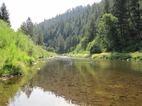
We’ve finally landed at a National Forest Service campground along the East Branch of the North Fork of the Feather River between Lake Almanor and Quincy.


Pictures L to R: Feather River; Feather River near Tobin Bridge; Tobin Bridge with a train crossing--where Dave nearly gave Peggy a heart attack; Coming into the Paradise Valley.
8 August 2009 Into Quincy and then onto Oroville, CA with a detour through Chico 136 miles
We had virtually no cell service at this NFS campground, and no electricity to charge the batteries. Last night when we got here, we walked around the short trails and down to the river, before building a campfire for the evening.
We decided to drive into Quincy before heading into Oroville today. The drive was beautiful, along the East Branch of the North Fork of the Feather River. We also passed Keedie, a small town named for a pioneer surveyor who engineered the route for the railroad along the Feather River in 1905. This rail bed is pretty impressive to see, as it is often about 60 feet above the river bed, on a small ledge in the cliff side. We spent the morning walking around Quincy, and then went into the Plumas County Museum. I love these small museums because they have such an eclectic mix of items on display. This museum really had some great displays highlighting their county’s history.
Back at the campsite, it was with happy sad feelings today as we broke camp—last night was the last night we will be sleeping in the tent for a while. However, I must admit...It will be nice to be in our own bed again! We headed south-southwest along this branch of the Feather River, winding with the curve of the river. Surprisingly, most of this route was downhill, which was nice, and also surprising to us...all along this branch of the river, PG & E has installed hydro-electric stations. David gave me a scare when he climbed up on a cement wall next to one of the bridges—the drop was straight down to the river about 200 feet below. I was not happy—even if I’d have been a rich widow if he had fallen!
It wasn’t until we came to the cutoff to Pulga that we had our last climb of our journey—albeit, a very small climb, before dropping down into the Lake Oroville area. The temperature was actually nice for this area in August—I don’t think it was even 85 degrees. We decided to head a little bit north to Chico/Durham area since we have time to kill, and we could do some antiquing before heading into Oroville.
We’ve checked into a hotel room for our last night…primarily so we can shower and look somewhat human for our homecoming. Plus, it is very hard to get a campsite on a Saturday night.


Beautiful Photos.......
ReplyDeleteEvery one should read this.....
Thanks for sharing this post with us......
___________________
DyanaDevis
Get easy cash at your door step
Best trekking agency in nepal
ReplyDeletewww.nepalholidaystrek.com